
-2.jpg)

About

Getting Around
Amsterdam is a compact city with excellent transport links. Schiphol airport (the fourth biggest in Europe) serves more than 200 destinations in 83 countries. There's an extensive motorway and railway network connecting the city nationally and internationally, and Amsterdam port is a significant destination for passenger liners and cargo ships. Public transport by bus, tram, metro or ferry is very reliable, and compared to London, for example, very cheap.
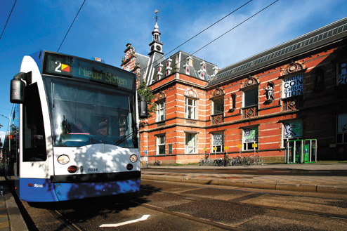
The best way of getting around the city centre is by bicycle (fiets). There are 400 kilometres of bike paths and a third of Amsterdam's residents use a bike to get to work. Motorists will probably find Amsterdam less convenient to negotiate. The queue for a residents' permit is measured in years, parking is expensive (there is no free parking in the centre), and drivers have to be on constant alert for bicycles and straying tourists. The ring road surrounding all of Amsterdam is the A10 and the last eastern stretch was completed in 1990. Traffic on the ring (in fact, traffic everywhere) can be heavy. The IJ tunnel (there are also tunnels east and west in the ring) connects the city centre with Amsterdam Noord. Water-based transport includes free ferries for passengers and their cycles that chug across the IJ all day, canal bikes and tour boats aimed at tourists, and water taxis for a more refined experience. Taxis can be ordered by phone or picked up at a rank and there are also taxi-cycles for an environmentally friendly trip. The North/South metro line is the city's biggest ongoing transport project made possible by developments in tunnel-digging technology, and is due to be completed in 2012. Travel information for Amsterdam, including location of car parks, can be found on www.bereikbaaramsterdam.nl. The municipal transport authority for Amsterdam is the GVB (www.gvb.nl) and their useful website includes info about tickets and transport routes to popular destinations (e.g. museums) using trams, the metro and buses. For national travel, www.9292ov.nl (Dutch) provides a door-to-door itinerary using all transport methods including ferries. The ticket system that operates on buses, trams and the metro is the 'strippenkart'. It’s a card with multiple strips that you stamp in a yellow on-board machine (it may also be stamped by a tram/bus conductor) according to the distance of the journey (one zone = two strips). This system is due to be replaced in January 2009 by the ov-chipkaart (PT Smart Card), a reloadable smart card system that will be used on all public transport. It is currently available just for the metro.
The best way of getting around the city centre is by bicycle (fiets). There are 400 kilometres of bike paths and a third of Amsterdam's residents use a bike to get to work. Motorists will probably find Amsterdam less convenient to negotiate. The queue for a residents' permit is measured in years, parking is expensive (there is no free parking in the centre), and drivers have to be on constant alert for bicycles and straying tourists. The ring road surrounding all of Amsterdam is the A10 and the last eastern stretch was completed in 1990. Traffic on the ring (in fact, traffic everywhere) can be heavy. The IJ tunnel (there are also tunnels east and west in the ring) connects the city centre with Amsterdam Noord. Water-based transport includes free ferries for passengers and their cycles that chug across the IJ all day, canal bikes and tour boats aimed at tourists, and water taxis for a more refined experience. Taxis can be ordered by phone or picked up at a rank and there are also taxi-cycles for an environmentally friendly trip. The North/South metro line is the city's biggest ongoing transport project made possible by developments in tunnel-digging technology, and is due to be completed in 2012. Travel information for Amsterdam, including location of car parks, can be found on www.bereikbaaramsterdam.nl. The municipal transport authority for Amsterdam is the GVB (www.gvb.nl) and their useful website includes info about tickets and transport routes to popular destinations (e.g. museums) using trams, the metro and buses. For national travel, www.9292ov.nl (Dutch) provides a door-to-door itinerary using all transport methods including ferries. The ticket system that operates on buses, trams and the metro is the 'strippenkart'. It’s a card with multiple strips that you stamp in a yellow on-board machine (it may also be stamped by a tram/bus conductor) according to the distance of the journey (one zone = two strips). This system is due to be replaced in January 2009 by the ov-chipkaart (PT Smart Card), a reloadable smart card system that will be used on all public transport. It is currently available just for the metro.


